Mira App
A Tool for Mobile Conservation Monitoring
~Nodge up your Monitoring and be more agile.~
Making sense of what we encounter in conservation work can sometimes be overwhelming. We have to understand if we do the right thing and if we have an impact? We have to know how we can measure our effectiveness?
Enter The Mira App: a free, open-source smartphone App that let you identify, record, and track critical indicators. Any individual or organization can use and customize the Mira App according to their conservation goals. It makes data collection and systematic monitoring possible even in the remotest places.
The App is based on principles of adaptive management. It facilitates participation across sectors, hierarchies and allows citizens’ involvement in in supporting the detection of threats and monitoring actions.
Real time data allows for immediate action
Various types of information such as numbers, text, units, GPS data and photographs can be stored and can be shared in real time to others in the team, project administrators and law enforcement authorities. This enhances comprehensive and rapid understanding of any changes at conservation sites, which could turn into threats and risks. Immediate actions can be suggested. In remote areas data will be stored offline in the APP.
Easy data flow and accessibility improves transparency
Easily import/export digital data between the App and other Desktop and Server Applications and formats (e.g. Miradi and Excel-CVS, XML). So that your paper work is minimized and you will have less time spent on the desk. It helps to have the data at the right place sorted and stored – accessible for your team.
Multiple devices with single user data create an enhanced management overview
Have multiple devices from various users recording data out in the field while keeping them synch with one monitoring/ data base file increases a common understanding for the whole management area as holistic approach.
Customize for effective individual needs
The data model can be customized and additional features added based on organizational structures and management needs.
Compatibility with the Open Standards for the Practice of Conservation enables streamlined management
Speaking the same language is essential. The App’s planning logic terminology, and color code follows the Open Standards and is coherent with the corresponding Miradi software. This allows for aligned/-streamlined management from the planning phase until the monitoring phase.
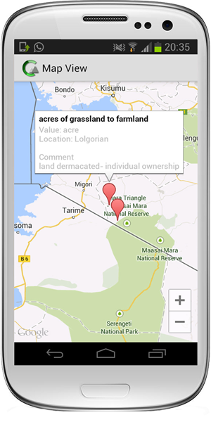
Quick data visualisation - maps & charts increases evaluation and learning capacities
The App allows for geo-tagging and display of data and indicators in online and offline maps. Furthermore the quick visualization of the recorded data through charts and diagrams improves the understanding for the situation in the conservation site and allows for reflection of your own work.
Citizen science for public awareness and increased monitoring actions
Through the adjustable data model design various public target groups can be adequately involved in monitoring activities and support conservation work systemically. Public awareness and understanding will be enhanced.
You want your project to become a Pilot Project?
You are a Developer and interested in joining the team?
MonitoringApp is currently under development and we are open to collaborating with conservation groups and donors to refine it.
Contact us: info@monitoringapp.net